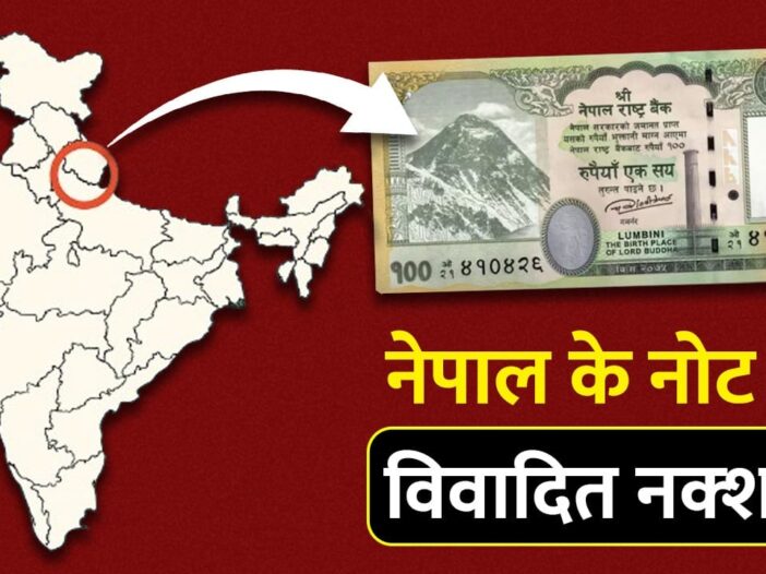
Nepal has once again taken such a step to provoke India, which may increase the tension between the two countries. In fact, on Thursday, the Central Bank of Nepal has issued a note of Rs 100, in which India’s Kalapani, Lipulekh and Limpiyadhura have been shown as part of Nepal. India has registered its objection to this step of Nepal and has said in clear tone that such action can sour the relations between the two countries. Let us tell you that even in the year 2020, there was tension between the two countries on this issue.
Responding to India’s objection, a statement has been issued by the Central Bank of Nepal (NRB) that there was already a map on the Rs 100 note. It has been changed as per the decision of the government. He told that out of the different notes like Rs 10, Rs 50 and Rs 500, only the Rs 100 note has the map of Nepal made on it.
In such a situation, it becomes important to know about the Sugauli Treaty of March 4, 1816, in which the Mahakali river has been described as the border of India and Nepal. It has been decided that India will have control over the area on the western side of the Mahakali river and Nepal will have control over the area on the eastern side.
If everything is clear in the Sugauli Treaty, then what is the real reason for the dispute between the two countries?
What is Sugauli Treaty, after which India-Nepal borders were decided?
When Prithvinarayan Shah laid the foundation of the Gorkha Empire in 1765, the process of unification of Nepal had started. By conquering small principalities and scattered states, he transformed Nepal into a powerful state. Their expansion soon made the Gorkhas a major force in the Himalayan region. But the ambitions of this emerging empire did not stop here. In 1790 he marched towards Tibet and attacked it. China came forward to protect Tibet and the Gorkhas had to retreat in front of the combined strength of both. This conflict of 1792 ended in a forced treaty, due to which the Gorkhas for the first time felt pressure to stop their expansion.
After the defeat in Tibet, the Gorkhas turned south and set their sights on the hilly areas bordering India. In the next 25 years he captured Sikkim, Garhwal and Kumaon. Their hold on the entire Himalayan strip became stronger, but this was the same time when the British were completely established in India. The increasing presence of Gorkhas on their borders became a danger signal for the East India Company. This tension finally took the form of war in 1814. The Gorkhas gave a tough fight in the British-Nepal war that lasted for almost two years, but ultimately they were defeated and could not stand against the British military power. In this conflict, Nepal had to lose almost two-thirds of its territory, although it had earlier gained this territory by occupying parts of India.
Even before the war completely ended, a historic agreement was signed between the two sides on 2 December 1815, which is called the Sugauli Treaty. This treaty was made at a place called Sugauli in Champaran district of Bihar. It was signed by Lieutenant Colonel Paris Bradash on behalf of the company and Rajguru Gajraj Mishra on behalf of Nepal. Despite being signed in December 1815, this treaty was formally considered effective from 4 March 1816. This agreement changed the borders of Nepal forever. He had to give up his claim on Sikkim, Garhwal and Kumaon. Before the war, Nepal’s expansion had spread up to Sutlej River in the west and Teesta River in the east, but after the Sugauli Treaty, it was limited to Mahakali in the west and Macchi River in the east. This was the moment which permanently decided the modern geographical form of Nepal.
There are 54 such places on the India-Nepal border on which there is dispute.
The Sugauli Treaty had decided that Nepal’s boundaries would extend to the Mahakali River in the west and the Macchi River in the east, but these boundaries were not clearly delineated in the treaty. This ambiguity became the basis of problems for both the countries in later years. Through which part of the river passes, where is its original source and in which direction does its flow affect the boundary line. Clear answers to these questions were not documented at that time.
Due to this incomplete description, today there are about 54 places on the border of India and Nepal where disputes arise from time to time. Areas like Kalapani-Limpyadhura, Susta, Macchi Valley, Tanakpur, Sandakpur, Pashupatinagar and Hile-Thori are often in discussion. It is estimated that the total area of these disputed parts could be around 60 thousand hectares. The root of the dispute is that both the countries have interpreted the treaty differently.
- India’s argument: India believes that the course and sources of the Mahakali river which is mentioned in the treaty are the same as are considered in boundary determination today and on this basis, India has been including many areas including Lipulekh in its official maps for a long time.
- Nepal’s argument: Nepal says that the river mentioned in the treaty has its origin in a place which India today considers as its part. Nepal argues that that branch of the river is the real Mahakali and the area falling to its west should also come within Nepal’s border.
This contrasting interpretation has over time made a historical agreement the basis of modern disputes. Both the countries have held several rounds of talks to determine the boundary, but due to the basic ambiguity of the treaty, this issue has still not been completely resolved.
There is a border dispute between the two countries for years
Border dispute has been going on between India and Nepal for years. In 1962, when there was a war between India and China, Nepal started claiming Lipulekh. After this dispute that lasted for many years, in the year 1981, a joint group was formed to divide the border between the two countries. Through this effort, almost 98 percent of the limits were fixed. After this, in the year 2000, Nepal’s Prime Minister Girija Prasad Koirala had requested Indian Prime Minister Atal Bihari Vajpayee to resolve this years-old dispute through talks. However, when in 2015 an agreement was reached between India and China to build a trade route through Lipulekh, Nepal lodged its objection to this agreement. Nepal said, India and China should have also asked before making this agreement.
Leave a Reply