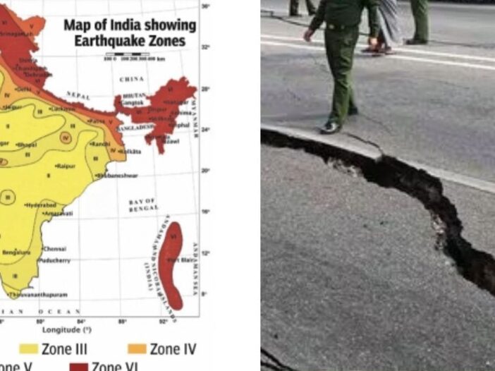
The danger of earthquake in India has now become more serious than before. This has been revealed from the map released recently by Bureau of Indian Standards (BIS). The seismic zonation map has, in a way, shaken the entire country. In this map, the entire Himalayan range from Kashmir to Arunachal Pradesh has now come in the highest danger Zone VI. In a way, this is an alert for the people living in these places.
According to the seismic zonation map, this is such a big change that 61 percent of the country’s area has moved from low and high risk zone III to VI, while 75 percent of the population lives in areas where the impact of earthquakes can prove fatal. In the old map, the Himalayas were divided into Zone IV and V, but new research has made it clear that the plates here have been locked for 200 years, which means stress is accumulating and the next big earthquake could be of 8.0 or more magnitude.
New code of 2025 implemented in new buildings
The seismic zonation map is part of the IS 1893 (Part 1): 2025 code, which has been implemented across the country from January 2025. Its objective is to make new buildings, bridges and highways earthquake-resistant, so that the loss of life and property is reduced. According to scientists, it is now believed that major earthquakes occurring in the Outer Himalayas may move southward and reach the Himalayan Frontal Thrust.
Special attention to security in new rules
The Bureau of Indian Standards (BIS) said that the new code of 2025 should be implemented in all new buildings, because now about three-fourths of India’s population lives in earthquake-prone areas. In the new rules, special attention has been paid to both structural and non-structural safety. For the first time, a rule has also been made that the heavy parts of any building, which are more than 1% of its total weight, should be tied firmly so that they do not fall in an earthquake and cause injuries.
What is seismic zonation map?
In simple words, it divides the country into four main zones based on earthquake risk – Zone II (low risk), Zone III (medium), Zone IV (high) and Zone V (very high) and now a new Zone VI (ultra-high) has been added. This map is based on Peak Ground Acceleration (PGA), which measures the intensity of ground shaking as a percentage of gravity (g).
Leave a Reply